Tuesday, August 31, 2010

Daily Diaries (8/29/10 - 8/30/10)

Date:  8/29/10
Trail Section:  Carvers Gap - US 19E
Distance:  14.4 miles

With Roan Mtn. at our back, we begin today with a climb to the top of Round Bald.  This is the first of a series of balds that we will climb today.  FYI, balds are areas on mountain tops where there are no trees. While none of the southern portion of the Appalachian Trail rises above the tree line, scientists are mystified as to why there are no trees.

On Round Bald the USFS is conducting an experiment to remove non-native plants on balds.  There is a herd of Angora goats that love these plants, especially Canadian blackberry which is taking over the balds.  Guarding these goats is a pair of Great Pyrenees dogs.  When I got near the fence these two dogs let me know, in no uncertain terms, I should leave.  The fence is an electric fence that is solar powered, and there are warnings to the curious hiker to keep off it.

About five miles into the hike we reach Overmountain Shelter.  The shelter is an old red barn that has been renovated into a shelter for hikers and served as a back drop in the movie “Winter People”.

With movies on my mind I could not help but think of Julie Andrews and the “The Hills Are Alive With The Sound Of Music” as we were on top of both Little Hump Mountain Bald and Hump Mountain Bald.  They reminded me of the scene where she was running across the top of the mountain and singing.  It was very pretty there.

Seasonally, on the top of Hump Mountain, there is a herd of longhorn cows.  We just missed the season and therefore, the cows.  It looked as if they had been moved within the last week.

After the vigorous climbs to the tops of all the balds, the five mile descent was not going to be outdone in how hard it was.  At times the descents were very steep and over large, loose rocks.  This was very hard on the feet and the legs.

Today’s hike was a beautiful hike that I would recommend to anyone fit enough for it.  If I have the opportunity to do it again, it will be a two to three day hike so that I can enjoy all the beauty there is at different times of the day.


Roan Mountain as seen from Round Bald


Great Pyrenees guard dog telling me to move on!


Angora goat telling me not to listen to dog


Overmountain Shelter


Hump Mountain Bald


Trail descending off Hump Mountain


Date:  8/30/10
Trail Section:  US 19E - Walnut Mtn. Rd
Distance: 10.4 miles

When we started this morning, the weather was cool and clear; however the vegetation was saturated with dew, thus we got very wet.  In addition to getting wet, this section of the trail was one of the most poorly marked sections that we have been on.  When we came to intersections with other trails we had to search for the right trail.  At times we had to go up the trails as much as 200 ft before we found a blaze letting us know we were on the right trail.

Other than these minor problems this was a pretty hike that was up and down.  It provided us with a couple of waterfalls, about a mile of hiking along a creek, and plenty of climbing.

This hike drove home the point to me the need for drinking, eating and resting periodically.  Due to the nature of the trail (not that strenuous or that hot), I nearly went too far without doing this.
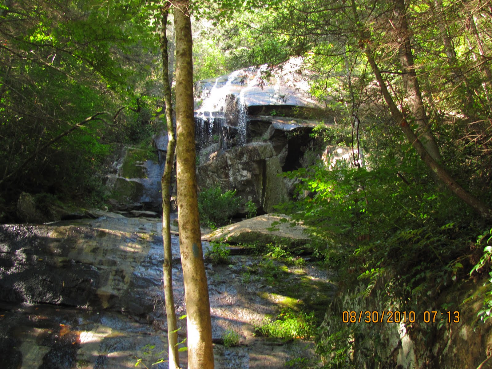


Jones Falls


A creek we followed for about a mile

Saturday, August 28, 2010

Daily Diaries (8/24/10 - 8/27/10)

Date:  8/24/10
Trail Section:  Iron Mtn. Gap - Indian Grave Gap
Distance:  11.2 miles

The morning temperatures are in the high 50s to low 60s...ideal for hiking. Starting at Iron Mtn. going south on the trail. The trail is ideal; wide smooth with a gentle incline.  It stays that way pretty much until Low Gap. At this point it begins getting progressively rockier and steeper.  From Low Gap, we climb approximately 1300 ft. to the top of Unaka Mtn.  (Unaka means 'white' in the Cherokee language).  Near the top we come across a large stand of Red Spruce.  On this hike we go through several areas where different vegetation is prominent: mature spruce at summit; young evergreens just below summit; below that, other green tunnel vegetation; large meadows where a farm had once been; and finally near the bottom, a burned area where the trees have not yet reestablished.

I had three creature encounters today (no pictures).  First, a fawn jumps in front of my vehicle.  The next encounter, I'm already on the trail and a deer in the brush right next to me spooks and runs.  To say that I was startled is an understatement!  Lastly, a deer approximately 50 ft. from me gets spooked.

Today was a moderately hard day but very enjoyable.


A unique tree among a stand of red spruce on Unaka Mtn.


Young evergreens


The green tunnel


A meadow


Date:  8/25/10
Trail Section:  Carvers Gap - Hughes Gap
Distance:  5.3 miles

This hike takes us over Roan Mtn.  Here there is a rhododendron garden that is supposed to be spectacular in June.  Unfortunately it is August, so we did not visit the garden.

The morning is chilly and very foggy and very wet (water streams were flowing down the middle of the trail in numerous places). It was cool in more ways than one.

Near the top of Roan Mtn. we visit Roan High Knob Shelter.  This is the highest shelter on the AT.  The shelter was built in 1933 by the CCC (an organization that was formed by Franklin Roosevelt to put people back to work during the great depression) to serve as the fire warden’s cabin.

The trail today was both some of the worst we have been on; and for at least a mile, it was the absolute best trail we have hiked.  The worst section was a very steep decent with large loose, slippery rocks.  The best was a gentle sloping wide trail consisting of mulched vegetation that was compressed and soft.  This was easy on the feet and legs.

The only critters seen today, with no pictures, were two woodchucks.
 

Roan High Knob Shelter


Can you see the trail??


The Trail in fog


Date:  8/27/10
Trail Section:  Hughes Gap - Iron Mtn. Gap
Distance:  9.2 miles

Today we relocate from Hot Springs, NC to Elizabethton, TN.

We start the day with a nice two mile 900 ft climb with the remainder of the day downhill except for three or four, 100 to 200 foot bumps in the trail.  The forest that we were hiking through was pretty, but not pictorial.  Along the way, we hike through an old apple orchard.  Lots of apples; but I could not get any to fall for me (darn it).  When we get back to Hughes Gap, we have a late lunch.  Just as we are getting ready to leave I find a chestnut.  Richard looks around and finds another.  We had lunch under a large chestnut tree. In our vehicles headed down the hill, we see more chestnuts in the road.  Now if we only had an open fire, we could have roasted chestnuts. We both were under the impression that chestnut trees were nearing extinction.

Of note on this hike, we meet a fellow hiker from the Asheville NC area, our age, who had served on the USS Oriskney in the sixties.  He was on board when a fire occurred that killed 44 crew members.  Ironically, as I was typing up this blog, I had the television on and the story of the sinking of the Oriskney as it was making a man-made reef off the coast of Florida was showing.  During the program, the story of the fire is televised.

Sorry no pictures today.

Monday, August 23, 2010

Daily Diaries (8/20/10 - 8/23/10)

Date:  8/20/10
Trail Section:  Sam's Gap - Spivey Gap
Distance:  13.4 miles

We have a long, foggy drive for parking the vehicles.  It's a beautiful day for a hike.  It's overcast when we start, and partly cloudy the remainder.  We have nice trails with open fields and a large bald (sort of a prairie on top of the mountain).  It was long and tiring, but good.

We encountered our first creatures that were satisfied to stand still for pictures today.  There were four doe and one fawn.  The deer, even though aware that we were there, did not feel the need to run off.  We spent several minutes looking at them and observing their actions (eating and looking at us).  We were fairly close to them.


Bambi says "hi"

After seeing the deer, we hiked on to Bald Mtn. where there were wild blueberries....which I partook of...they were delicious.  Bald Mtn. has two peaks, the blueberries were on the southern peak.  The locals knew of the blueberries.  We passed four ladies from the area who were on their way to the top to pick berries.  They didn't seem to have a problem climbing the mountain and talking at the same time.  Once on top of the peak, in addition to the berries were great views.


Bald Mtn.


Wild blueberries

It was a long day with the driving and the hike, but worth it.


Date:  8/21/10
Trail Section:  Spivey Gap - Chestoa Bridge (over the Nolichucky River)
Distance:  11.2 miles

It was overcast all day today with rain during the last half of the hike.  It was great for hiking, but not for viewing.  On this hike we passed areas that were filled with nothing but dead or downed trees....almost as if a fire had hit the area.  It was the typical up and down hike that the AT has to offer; green tunnel broken by the dead areas.  There were some great views of the Nolichucky River when we got near the end of the hike.


Nolichucky River

The shelter that we passed along the way was surrounded by large Fraser magnolias and mammoth hemlocks.  However, due to their size, location and the weather, was unable to get any decent photos.


Date:  8/23/10
Trail Section:  Indian Grave Gap - Chestoa Bridge
Distance:  8.3 miles

Clear, mild weather with a gentle downhill hike most of the time; some bad rock the rest.  What more can I say....Great!  Was not nearly as sweaty a hike as the other days.

I saw my first orange salamander and we crossed our first railroad track on the AT.  The hike was so easy, it was almost boring....not really.


Orange salamander


First railroad track encountered on the AT

Thursday, August 19, 2010

Daily Diaries (8/17/10 - 8/18/10)

Date:  8-17-10
Trail Section:  Blackstack Cliff - Devil Fork Gap
Distance:  12.1 miles

Today starts off very foggy. We start in very heavy vegetation which turns into large rocks that we scramble over to a ridge. Views from the ridge are finally clear and awesome. Off the ridge and to my shelter, “Jerry’s Cabin”.  The shelter is rather run down and messy.  From there, it is on the trail again through very thick briar patches with a very narrow path for walking.


Foggy Morning


Heavy vegetation and large rocks


More heavy vegetation


My shelter - how did they know I was here??


On this hike we see:

* Andrew Johnson Mountain named after the president who was VP under Abraham Lincoln.  In addition he was from Tennessee.

*The final resting place for an uncle and nephew who had enlisted in the Union Army during the Civil War. They were ambushed and killed by Confederate Troops while returning to a family gathering.


Tombstone of William Shelton


Tombstone of David Shelton

*A wild turkey that wanted to stay on the trail just ahead of me until I got the camera out to take its picture; then it disappeared into the thick brush.

* On the way to get Richard's vehicle, two doe and a fawn decided to run down the road in my lane for 200 to 300 feet. I was concerned that one of them was going to turn around and tell me to get off their road.

We did get rained on. All in all a great day for a great hike.
 
 
Date:  8-18-10
Trail Section:  Blackstack Cliff - Alan Gap
Distance: 8.2 miles

Like yesterday, today starts with fog at Blackstack Cliff.  Other than some great views of the mountains at White Rock Cliffs and mushrooms that are dying, we did not see much.  It was just a great hike with the beautiful mountain trails.  Due to the rain last night it was very humid.


View from White Rock Cliff


Mushroom in final stage


Another mushroom in its final stage

Wednesday, August 18, 2010

Some Pix (8/10/10 - 8/14/10)

Following are some photos I managed to upload today:


Early morning view as we drive to the start of the next trailhead


Tall grass along the trail


Green mushroom


Truckin' along - Tom & Richard


A blurry privvy


Max Patch


The Hikers:  l-r, Tom, Jerry, Richard, Ted


The green tunnel

Monday, August 16, 2010

Daily Diaries (8/09/10 - 8/15/10)

Hiker's Note:  since it's taking centuries to upload the many photos I've taken along my hike, I'll stick mostly to written diaries for the time being.  I plan to add more photos later because I want to share what I'm seeing!

Date:   8/09/10
Trail Section:   Tangard Gap - Hot Springs, NC
Distance:   5.9 Miles

This was an easy hike.

The hike starts where, at one time, there was a farm. The forest has been allowed to recapture the land; however, there are still several large apple trees in the area, a small pond and an old dam. The apple trees are loaded with apples; but they are not ripe, so no apples. At the pond, bat houses have been erected.  The construction of these houses is interesting in that the bats have to enter by crawling up the inside from the bottom, instead of entering through a hole in the side.

From the pond area we begin to drop off the top by a lovers leap and with views of the French Broad River. This river runs through Hot Springs and is a favorite rafting site for people in the area.


French Broad River at Lover's Leap

This hike was very humid.  Even though it was an easy hike, our clothes were saturated.


Date:   8/10/10
Trail Section:   Alan Gap - Tangard Gap
Distance:   8.8 Miles

This is a nice hike through the green tunnel of vegetation. On this hike we were able to hike up a fire tower at the top of Rich Mountain. The humidity was so great that even though we could see vistas they were not clear due to the haze. By this time we were drenched from our sweat, so we took off our shirts so that they could dry some while on the tower, this did not work.  Even though we did not have vistas, there were plenty of flowers, mushrooms and birds.

Slack packing is so much better than hiking with a full backpack!


The Trail

 
Date:   8/11/10
Trail Section:   Sam's Gap - Devil's Fork Gap
Distance:   8.5 Miles
 
Richard and I are sort of bouncing around on the trail.  This is due to the way we are hiking (slack packing), the weather conditions, and the fact that my cousin Tom, and a friend from NC Ted, will be joining us this weekend.  However, when we are finished for this year, we will have hiked the entire segment between Green Road, TN and Damascus, VA.
 
This portion of the hike was through what had mostly been farms. During this hike we ran into a couple of men with the National Forest Department.  They were removing non-indigenous growth that is continuing to grow in the area.
We start the hike through some very high grasses and follow an old fence for a great deal of the hike. Early in the hike we were on a ridge where there was a breeze, which made the hike comfortable.  We then dropped off the ridge, and the air became very still and humid (uncomfortable).

Near the end of the hike at about mile 6 or 7 we came across 2 graves. One of a woman born in 1865.  She died 3 days short of being 100 years old. The other, a man who died at 90.  He was born in 1877. Don’t know their relationship even though they were buried side by side. To think that they lived as long as they did without the benefit of modern medicine. Think maybe hard work and natural foods helped genetics?

It was another hot and humid day, but a great day for hiking.
 
 
Date:   8/13/10
Trail Section:   Lemon Gap - Garenflo Gap
Distance:   7.8 Miles
 
Great hike with gentle uphill climbs and gradual downhills. On this hike, we met a group of college freshmen from Davidson College.  The hike is are part of their freshmen orientation. While following the group I have 6 close encounters of the stinging kind....a swarm of angry ground wasp (probably yellow jackets) decide to attack me. So much for the fun part of the hike.


Date:   8/14/10
Trail Section:   Max Patch - Lemon Gap
Distance:   6.2 Miles

After a nice climb to the top of Max Patch, it is a pretty and gentle decent into Lemon Gap. Max Patch is a bald that was a farm in the early 1900’s.  It has since became a part of the AT and is kept from being overgrown. It is known as the jewel of the AT. On the patch blackberries are abundant.  We force ourselves to sample quite a few. No excitement today.


Date:   8/15/10
Trail Section:   Garenflo Gap - Rock Springs
Distance:   6.4 Miles

This is the last day that Tom and Ted will be hiking with us. It is just a wonderful hike.

Thursday, August 12, 2010

Getting Started Again (8/07/10)

8-7-10 Green Rd. to Max Patch Road
12.8 Miles

Back on the trail at last. For this section of the walk, Richard and I plan on going from Green Rd. in Tennessee to Damascus Virginia and call it quits for this year. In addition we are planning on doing the hike different. We will be doing what is known as slack packing a lot. We will park a vehicle where we plan on starting the day and another where we plan on ending the day, then hike from one vehicle to the other with only a day pack which has water, food and rain gear. We will not be taking any of the other gear that will be needed for overnight camping. Looking at maps of this section of the trail we should be able to do this a lot.

We start today by dropping off Richard's vehicle at Max Patch. While at Max Patch, Richard sees two men, that we saw in the restaurant at breakfast, and starts talking with them. They were replacing fence that is used to keep vehicles off Max Patch. The fence was torn down so that emergency vehicles could get up close to the top of Max Patch. A young woman was struck by lightning there, earlier this year.

At Green Road we start off with a 1300 foot climb for the first two miles, after that it was up and down with several 500 and 600 ft/mile climbs. Unlike earlier this year, everything was green, we were walking in a green tunnel. The most amazing thing on this section was the mushrooms; they are all different colors (reds, browns yellows and colors in between). Some mushrooms when mature die and rot.  At this point they smell like rotting flesh; flies love them. When the flies land on them and eat, they leave with mushroom spore on their bodies and spread the mushrooms' fungus. And the life cycle goes on.


Starting out this leg:  Green Rd., TN


Colorful mushrooms along the trail


Due to the foliage there was little breeze so the air was warm and very humid. One spot where there is a clearing was at a Bald, called Snow Bird. There was a cool breeze that is almost chilly due to our clothes that were wet from sweat. At Snow Bird there was a navigation station that is used by airplanes. From Snow Bird we drop into Deep Gap where we stop to get water and eat lunch at Ground Hog Creek Shelter. At the shelter there were hundreds of butterflies, it was a beautiful sight. Prior to leaving the shelter a group of young boys (12 to 15 years of age) come up followed by three riders on horses. Horses are not supposed to be on this section of the trail. The boys planned on staying the night at the shelter. We were glad we were not staying at the shelter.


Snow Bird Bald


From Deep Gap we still had 5.6 miles to hike. After being lazy for 3 months our butts were dragging, and our hiking time showed it. It took almost four hours. To make matters worse, the drive back to Green Road to pick up my vehicle took well over 2 hours due to an accident on I-40. We got back to the motel at 11:00 pm - a long day. The first day and 12.8 miles down. We will be taking 8-8-10 off to recoup.