- April 16th I was grounded for shin splints, in Hot Springs, NC. Come Monday morning (4/19), my shin was still hurting. Due to this, I returned to the doctor. During the meeting with the doctor, I asked him to look at what I thought was bad chafing from my backpack. Upon examination he informed me that it was not chafing...it was shingles and put me on medication for it. He had no idea as to how long it would take for me to get over the shingles. I had been struck by the double shins (SHIN splints and SHINgles). After thinking it through, Richard and I decided we should come home for awhile. Thankfully cousin Tom and Nancy were there to help us again. We got back to Phoenix last night. My shin splints and shingles are still hurting; but I am recuperating. We plan to return to the trail, but are not sure when. I will let everyone know when. Thank you all for your comments and support during this adventure.
Sunday, April 25, 2010
Hot Springs, NC to Phoenix, AZ (4/17/10 - 4/25/10)
Wednesday, April 21, 2010
Gatlinburg, TN to Hot Springs, NC (4/12/10 - 4/16/10)
April 13
A couple things I forgot from the earlier post:


April 14


April 15


April 16
A couple things I forgot from the earlier post:
- With the smell around Clingman's Dome, I could not help but think of Christmas. Got kind of homesick.
- There were numerous large trees uprooted due to the weather this last winter. See the picture below of Richard looking at a tree with a huge boulder imbedded in its roots; and notice the size of the root system compared to Richard.

- Leaving Gatlinburg was beautiful. There were lots of flowering trees....dogwoods, some sort of pink trees.
- A nice climb out of Newfound Gap
- After the climb, we walked the ridges of the mountains most of the day. There were times the trail was only about a yard wide with a several hundred foot drop-off on both sides.
- With the evergreens in the mountains, it reminded us of the Rockies.
- Stopped at Pecks Corner Shelter
- Hiked 10.4 miles

One of the ridges, not the narrowest, but narrow enough.
The drop-off on either side is
hundreds of feet and very steep.
April 14
- Today is another beautiful day for hiking.
- Passed a large stand of spruce that had died. The same problem that the evergreens are having in the west is hitting here.
- My right shin has started hurting today.
- Stopped at Cosby Knob shelter
- Hiked 12.9 miles

Tricorners Shelter
At this shelter, a bear stole a hiker's backpack while
he was hanging his food bag.
This is a few days after that happened.

A stand of dead spruce

A waterfall where a downed
log is acting as a chute for the water
April 15
- Started early again today; mostly downhill hiking; shin still hurting
- When we got to Davenport Gap, we discovered Trail Angels had left sodas and candy bars for hikers. What a treat!!
- Leaving Davenport Gap, we are leaving the Smokies
- After Davenport Gap, we follow a stream with waterfalls and beautiful flowering trees down to the Pigeon River.
- After the river, we pass under Interstate 40, our first interstate.
- We had planned on stopping at Standing Bear Farms hostel for pizza, then continuing hiking for another two miles, but my shin is hurting bad enough that we stop for the night.
- This was our first hostel. Kind of like the shelters....wooden slats with thin mattresses for a bed and a lot of hikers (most of them young)
- An experience, but not for some of us older hikers. Would have been a great experience if we were younger.
- Hiked 10.4 miles

Dogwoods in bloom alongside the Pigeon River

Interstate 40 - closed due to a rock slide

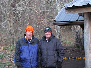
Richard and me at the Standing Bear Farms hostel
April 16
- Woke up this morning and I could hardly walk. We decided to take a shuttle to Hot Springs, NC.
- Went to a doctor in Hot Springs. Doc grounded me. Diagnosis: shin splints. I'm supposed to take Advil and rest until Monday. On Monday, if I can walk around Hot Springs with my pack on and if it doesn't hurt, I can start hiking again.
Monday, April 12, 2010
Fontana Dam, NC to Gatlinburg, TN (4/7/10 - 4/11/10)
April 7

April 8

April 9

April 10
Two stories here:
Bears - The food supply at some elevations in the Smoky's has been so scarce that the mother bears went into hibernation without enough fat stored up, and they died during the winter. Their bear cubs are coming out of hibernation without a mother and are starving. Some have been rescued. This means that the bears will be more aggressive this year.
Turkey - Some hikers told us that at one of the shelters when the weather was so bad, there was a turkey who attempted to roost on top of the shelter. The wind was so bad and the roof was metal; the turkey slid off several times. The turkey finally gave up, went into the shelter that was full of hikers and spent the night!
April 11


We'll stay in Gatlinburg until April 13, when we'll start the next leg to Hot Springs which will probably take us six days. Til then.....
- Crossed our first dam on the AT (Fontana Dam on the Little Tennessee)
- Entered the Great Smoky Mountain National Park right after crossing the dam
- It was a long, hard climb out of Fontana
- Stayed at Mollies Ridge Shelter
- Hiked 11 miles

Fontana Dam - Little Tennessee River
- Getting ready to leave and a storm with lightening arrives; stay put for awhile
- Around 11 a.m., a ridge runner (an AT person who monitors the trail) informs us that the shelter is booked full for the night and that we would have to either hike on to the next shelter or set up our tents outside the shelter. We opted to move on to the next shelter 2.5 miles away.
- We arrived at Russell Field Shelter soaking wet.
- This shelter has a chain link fence over the front of it to keep bears out.
- Late in the evening, three young men from Ohio arrive. They are also soaked. They are section hiking rather than through hiking.
- Hiked only 2.5 miles

Russell Field Shelter
- Weather this morning is clear and cold; great after the rain.
- We start out by climbing, for the first five miles, over a mountain called Rocky Top to the top of one called Thunderhead.
- The views from Rocky Top were fantastic.
- Between Rocky Top and Thunderhead, the tree branches were covered with ice.
- From Thunderhead, it was a steep downhill trek into Derrick Knob Shelter where we spent the night.
- Hiked 9.2 miles

Iced Tree Branches
- Fairly easy hike today. We decided to keep today's hike short so that we can go into Gatlinburg tomorrow night for supplies.
- We hike into Double Springs Shelter, 7.2 miles
- Two volunteer trail maintainers (Mack and Tom) stay the night at the shelter too. One of them has an mp3 player with a set of small speakers. Went to bed listening to some good bluegrass.

Mack & Tom - Volunteer Trail Maintainers
Bears - The food supply at some elevations in the Smoky's has been so scarce that the mother bears went into hibernation without enough fat stored up, and they died during the winter. Their bear cubs are coming out of hibernation without a mother and are starving. Some have been rescued. This means that the bears will be more aggressive this year.
Turkey - Some hikers told us that at one of the shelters when the weather was so bad, there was a turkey who attempted to roost on top of the shelter. The wind was so bad and the roof was metal; the turkey slid off several times. The turkey finally gave up, went into the shelter that was full of hikers and spent the night!
April 11
- Climbed out of Double Springs Gap to Clingman's Dome--the highest point on the AT (6,643 ft). The views from the observation tower are stunning.
- Coming off the Dome, we hike in snow making footing very slippery.
- The hike into Newfound Gap is a long downhill hike, hard on the feet.
- At Newfound Gap, a trail maintainer from Vermont gives us a ride into Gatlinburg. Don't remember his name.
- Hiked 10.8 miles
- WE'VE SURPASSED THE 200 MILE MARK!!

Clingman's Dome Observation Tower

Descending Clingman's Dome

Me Crossing Another Stateline
We'll stay in Gatlinburg until April 13, when we'll start the next leg to Hot Springs which will probably take us six days. Til then.....
Tuesday, April 6, 2010
Jerry's Birthday, Easter & Next Day (4/3/10 - 4/5/10)
April 3

April 4

April 5

- Happy Birthday to me! Breakfast at the Nantahala Outdoor Center (was great and southern)
- Climbed out of the Nantahala Gorge--3,000 feet in 6 miles. Thought we were never going to make it to the top.
- Weather was great for hiking--overcast with breezes.
- Made it to Sassafras Gap.
- Hiked 6.9 miles

Nantahala River - Our First River Crossing
April 4
- Shelter at Sassafras Gap was full last night; hard to sleep.
- Hard climbing today too. Steep climb on the front of the day; but the killer was the climb at the end of the day. The climb was steeper than Squaw Peak which I have done in the past; but never with a 45 pound pack on my back.
- Richard saw our first animal today....a small snake.
- I got to wish everyone a Happy Easter except for Julie (she was working). It was great hearing everyone's voice; miss them all.
- Made it to Brown Fork Gap shelter (is an old shelter, made of logs).
- Hiked 9.1 miles

Brown Fork Gap Shelter
- Headed to Fontana Dam, NC today 11.1 miles
- Climbing out of the shelter area: 600 ft. the first mile, then downhill until lunch, then an 800 ft. climb over less than 2 miles and an 1,800 ft. descent for the last 3 miles. A real leg killer!
- Butt's dragging, legs, feet and back hurting. When will this get any easier??!!
- Staying at the Fontana Dam Resort for the next 2 nights.
- Hiked 11.6 miles

A Trillium - Our First of the Trip
Saturday, April 3, 2010
Wallace Gap to Nantahala Outdoor Center (3/31/10 - 4/2/10)
This portion of the hike takes us from Wallace Gap at Franklin, NC to the Nantahala Outdoor Center at Wesser, NC.
March 31 (Wallace Gap - USFS 69)

April 1 (April Fool's Day)


April 2

March 31 (Wallace Gap - USFS 69)
- Today was a good hike. Saw a pretty little waterfall and our first bald (Siler Bald). A bald is a large grassy area without any trees at the top of a mountain. There are several speculations as to why there are no trees, but it's all guesswork.
- Hiked 11.4 miles

- After hiking only about 2.5 miles up the trail, got to Wayah Bald where there is a stone observation tower built in 1937. Beautiful vistas. Took about an hour break.
- Hiked to a place that was only listed as a spring. Rotten place to pitch a tent, however we did.
- Hiked 10.3 miles


- During the night, heard what we think were fox yipping several times; and awoke this morning to a wild turkey gobbling.
- Today we visited Wesser Bald observation tower (just a steel structure)
- It was a hot day and we made it to Nantahala Outdoor Center
- Hiked 9.3 miles

Subscribe to:
Comments (Atom)